|
|
|||||||||||||||||
| Point ID: 8200 | Downloads | Plots | Site Data | Code: 8195 |
|
|
|||||||||||||||||
| Download | |
|---|---|
| Site Descriptor Information | Site Time Series Data |
| Link to all available data | |
| View: | Time Series | All |
| Units: | m3/s |
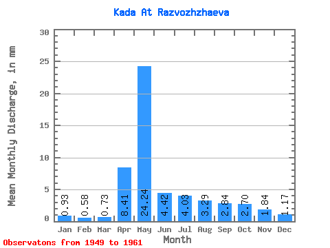
| Statistic | Jan | Feb | Mar | Apr | May | Jun | Jul | Aug | Sep | Oct | Nov | Dec | Annual |
|---|---|---|---|---|---|---|---|---|---|---|---|---|---|
| Mean | 0.93 | 0.59 | 0.73 | 8.41 | 24.24 | 4.43 | 4.03 | 3.29 | 2.84 | 2.69 | 1.84 | 1.17 | 56.02 |
| Standard Deviation | 0.60 | 0.47 | 0.53 | 5.77 | 13.43 | 1.90 | 2.50 | 1.17 | 1.17 | 0.98 | 0.64 | 0.39 | 15.24 |
| Min | 0.24 | 0.07 | 0.04 | 2.20 | 9.23 | 1.94 | 1.34 | 2.15 | 1.78 | 1.67 | 1.32 | 0.60 | 37.52 |
| Max | 2.34 | 1.61 | 1.53 | 17.94 | 56.43 | 9.40 | 9.78 | 5.81 | 5.62 | 4.81 | 3.29 | 2.20 | 83.67 |
| Coefficient of Variation | 0.65 | 0.81 | 0.73 | 0.69 | 0.55 | 0.43 | 0.62 | 0.35 | 0.41 | 0.36 | 0.35 | 0.34 | 0.27 |
 Return to R-Arctic Net Home Page