|
|
|||||||||||||||||
| Point ID: 8167 | Downloads | Plots | Site Data | Code: 8127 |
|
|
|||||||||||||||||
| Download | |
|---|---|
| Site Descriptor Information | Site Time Series Data |
| Link to all available data | |
| View: | Time Series | All |
| Units: | mm |
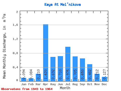
| Statistic | Jan | Feb | Mar | Apr | May | Jun | Jul | Aug | Sep | Oct | Nov | Dec | Annual |
|---|---|---|---|---|---|---|---|---|---|---|---|---|---|
| Mean | 0.09 | 0.08 | 0.21 | 1.62 | 0.69 | 0.71 | 0.97 | 0.70 | 0.65 | 0.48 | 0.21 | 0.13 | 0.55 |
| Standard Deviation | 0.07 | 0.07 | 0.18 | 0.72 | 0.41 | 0.55 | 1.02 | 0.41 | 0.40 | 0.21 | 0.12 | 0.07 | 0.25 |
| Min | 0.00 | 0.00 | 0.00 | 0.18 | 0.17 | 0.27 | 0.24 | 0.32 | 0.20 | 0.20 | 0.06 | 0.01 | 0.23 |
| Max | 0.23 | 0.21 | 0.74 | 2.78 | 1.68 | 2.95 | 4.85 | 1.78 | 2.05 | 0.89 | 0.60 | 0.25 | 1.37 |
| Coefficient of Variation | 0.70 | 0.79 | 0.87 | 0.45 | 0.60 | 0.77 | 1.04 | 0.58 | 0.62 | 0.44 | 0.56 | 0.53 | 0.45 |
 Return to R-Arctic Net Home Page