|
|
|||||||||||||||||
| Point ID: 8167 | Downloads | Plots | Site Data | Code: 8127 |
|
|
|||||||||||||||||
| Download | |
|---|---|
| Site Descriptor Information | Site Time Series Data |
| Link to all available data | |
| View: | Time Series | All |
| Units: | m3/s |
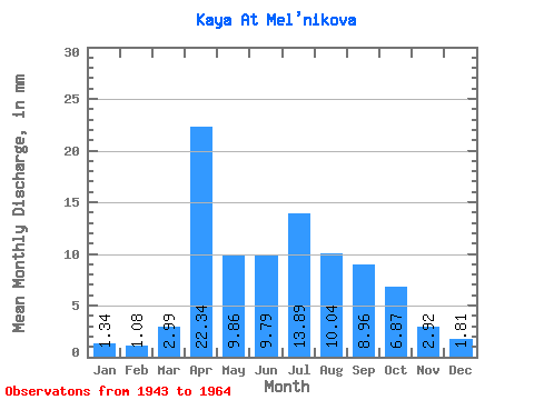
| Statistic | Jan | Feb | Mar | Apr | May | Jun | Jul | Aug | Sep | Oct | Nov | Dec | Annual |
|---|---|---|---|---|---|---|---|---|---|---|---|---|---|
| Mean | 1.34 | 1.09 | 2.98 | 22.34 | 9.86 | 9.79 | 13.88 | 10.05 | 8.97 | 6.87 | 2.92 | 1.81 | 92.56 |
| Standard Deviation | 0.94 | 0.86 | 2.59 | 10.00 | 5.91 | 7.57 | 14.48 | 5.79 | 5.56 | 3.03 | 1.63 | 0.95 | 41.30 |
| Min | 0.00 | 0.00 | 0.00 | 2.48 | 2.42 | 3.72 | 3.42 | 4.56 | 2.76 | 2.85 | 0.83 | 0.14 | 38.55 |
| Max | 3.28 | 2.73 | 10.54 | 38.33 | 23.93 | 40.67 | 69.09 | 25.36 | 28.26 | 12.68 | 8.27 | 3.56 | 230.04 |
| Coefficient of Variation | 0.70 | 0.79 | 0.87 | 0.45 | 0.60 | 0.77 | 1.04 | 0.58 | 0.62 | 0.44 | 0.56 | 0.53 | 0.45 |
 Return to R-Arctic Net Home Page