|
|
|||||||||||||||||
| Point ID: 8160 | Downloads | Plots | Site Data | Code: 8080 |
|
|
|||||||||||||||||
| Download | |
|---|---|
| Site Descriptor Information | Site Time Series Data |
| Link to all available data | |
| View: | Time Series | All |
| Units: | mm |
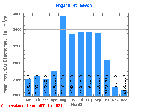
| Statistic | Jan | Feb | Mar | Apr | May | Jun | Jul | Aug | Sep | Oct | Nov | Dec | Annual |
|---|---|---|---|---|---|---|---|---|---|---|---|---|---|
| Mean | 2402.00 | 2487.00 | 2422.00 | 2608.50 | 3916.00 | 3493.00 | 3530.50 | 3550.00 | 3516.50 | 2873.25 | 2216.35 | 2162.50 | 2931.47 |
| Standard Deviation | 810.99 | 902.71 | 850.22 | 909.61 | 675.10 | 697.88 | 590.21 | 495.95 | 530.45 | 751.40 | 960.75 | 760.90 | 366.61 |
| Min | 1140.00 | 1360.00 | 1300.00 | 1490.00 | 2830.00 | 2350.00 | 2850.00 | 2870.00 | 2850.00 | 905.00 | 679.00 | 1060.00 | 2337.50 |
| Max | 3880.00 | 4460.00 | 4260.00 | 4380.00 | 5240.00 | 4720.00 | 4730.00 | 4480.00 | 4720.00 | 3870.00 | 3960.00 | 3770.00 | 3611.67 |
| Coefficient of Variation | 0.34 | 0.36 | 0.35 | 0.35 | 0.17 | 0.20 | 0.17 | 0.14 | 0.15 | 0.26 | 0.43 | 0.35 | 0.12 |
 Return to R-Arctic Net Home Page