|
|
|||||||||||||||||
| Point ID: 8160 | Downloads | Plots | Site Data | Code: 8080 |
|
|
|||||||||||||||||
| Download | |
|---|---|
| Site Descriptor Information | Site Time Series Data |
| Link to all available data | |
| View: | Time Series | All |
| Units: | m3/s |
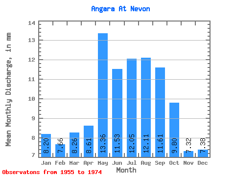
| Statistic | Jan | Feb | Mar | Apr | May | Jun | Jul | Aug | Sep | Oct | Nov | Dec | Annual |
|---|---|---|---|---|---|---|---|---|---|---|---|---|---|
| Mean | 8.19 | 7.73 | 8.26 | 8.61 | 13.36 | 11.53 | 12.04 | 12.11 | 11.61 | 9.80 | 7.32 | 7.38 | 117.86 |
| Standard Deviation | 2.77 | 2.81 | 2.90 | 3.00 | 2.30 | 2.30 | 2.01 | 1.69 | 1.75 | 2.56 | 3.17 | 2.60 | 14.74 |
| Min | 3.89 | 4.23 | 4.43 | 4.92 | 9.65 | 7.76 | 9.72 | 9.79 | 9.41 | 3.09 | 2.24 | 3.62 | 93.98 |
| Max | 13.24 | 13.86 | 14.53 | 14.46 | 17.88 | 15.59 | 16.14 | 15.28 | 15.59 | 13.20 | 13.08 | 12.86 | 145.20 |
| Coefficient of Variation | 0.34 | 0.36 | 0.35 | 0.35 | 0.17 | 0.20 | 0.17 | 0.14 | 0.15 | 0.26 | 0.43 | 0.35 | 0.12 |
 Return to R-Arctic Net Home Page