|
|
|||||||||||||||||
| Point ID: 8155 | Downloads | Plots | Site Data | Code: 8056 |
|
|
|||||||||||||||||
| Download | |
|---|---|
| Site Descriptor Information | Site Time Series Data |
| Link to all available data | |
| View: | Time Series | All |
| Units: | mm |
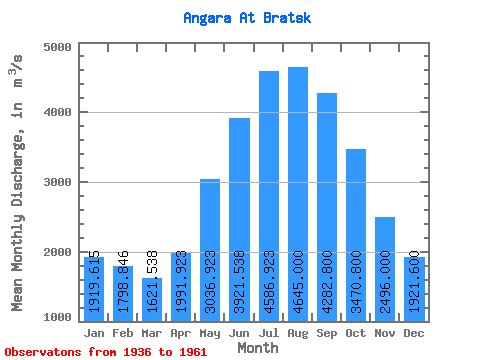
| Statistic | Jan | Feb | Mar | Apr | May | Jun | Jul | Aug | Sep | Oct | Nov | Dec | Annual |
|---|---|---|---|---|---|---|---|---|---|---|---|---|---|
| Mean | 1919.62 | 1798.85 | 1621.54 | 1991.92 | 3036.92 | 3921.54 | 4586.92 | 4645.00 | 4282.80 | 3470.80 | 2496.00 | 1921.60 | 2972.33 |
| Standard Deviation | 283.54 | 306.61 | 264.80 | 568.55 | 542.70 | 611.68 | 915.93 | 781.12 | 685.95 | 579.42 | 540.65 | 282.51 | 368.30 |
| Min | 1360.00 | 1280.00 | 1240.00 | 1370.00 | 2290.00 | 2960.00 | 3230.00 | 3260.00 | 2980.00 | 2180.00 | 1540.00 | 1430.00 | 2303.33 |
| Max | 2370.00 | 2280.00 | 2060.00 | 3270.00 | 4530.00 | 5240.00 | 7150.00 | 6270.00 | 5380.00 | 4610.00 | 3400.00 | 2570.00 | 3634.17 |
| Coefficient of Variation | 0.15 | 0.17 | 0.16 | 0.28 | 0.18 | 0.16 | 0.20 | 0.17 | 0.16 | 0.17 | 0.22 | 0.15 | 0.12 |
 Return to R-Arctic Net Home Page