|
|
|||||||||||||||||
| Point ID: 8155 | Downloads | Plots | Site Data | Code: 8056 |
|
|
|||||||||||||||||
| Download | |
|---|---|
| Site Descriptor Information | Site Time Series Data |
| Link to all available data | |
| View: | Time Series | All |
| Units: | m3/s |
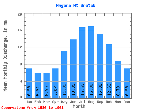
| Statistic | Jan | Feb | Mar | Apr | May | Jun | Jul | Aug | Sep | Oct | Nov | Dec | Annual |
|---|---|---|---|---|---|---|---|---|---|---|---|---|---|
| Mean | 6.99 | 5.96 | 5.90 | 7.01 | 11.05 | 13.81 | 16.69 | 16.90 | 15.08 | 12.63 | 8.79 | 6.99 | 127.45 |
| Standard Deviation | 1.03 | 1.02 | 0.96 | 2.00 | 1.98 | 2.15 | 3.33 | 2.84 | 2.42 | 2.11 | 1.90 | 1.03 | 15.79 |
| Min | 4.95 | 4.24 | 4.51 | 4.83 | 8.33 | 10.42 | 11.75 | 11.86 | 10.49 | 7.93 | 5.42 | 5.20 | 98.77 |
| Max | 8.62 | 7.56 | 7.50 | 11.52 | 16.48 | 18.45 | 26.02 | 22.81 | 18.95 | 16.77 | 11.97 | 9.35 | 155.84 |
| Coefficient of Variation | 0.15 | 0.17 | 0.16 | 0.28 | 0.18 | 0.16 | 0.20 | 0.17 | 0.16 | 0.17 | 0.22 | 0.15 | 0.12 |
 Return to R-Arctic Net Home Page