|
|
|||||||||||||||||
| Point ID: 8154 | Downloads | Plots | Site Data | Code: 8045 |
|
|
|||||||||||||||||
| Download | |
|---|---|
| Site Descriptor Information | Site Time Series Data |
| Link to all available data | |
| View: | Time Series | All |
| Units: | mm |
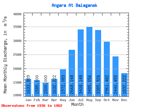
| Statistic | Jan | Feb | Mar | Apr | May | Jun | Jul | Aug | Sep | Oct | Nov | Dec | Annual |
|---|---|---|---|---|---|---|---|---|---|---|---|---|---|
| Mean | 1633.89 | 1585.00 | 1500.00 | 1632.22 | 1972.08 | 2668.15 | 3408.15 | 3485.56 | 3385.93 | 2961.48 | 2440.45 | 1832.22 | 2316.52 |
| Standard Deviation | 271.67 | 280.68 | 308.39 | 356.18 | 281.62 | 472.39 | 785.18 | 630.39 | 575.56 | 538.94 | 472.34 | 352.20 | 316.70 |
| Min | 1260.00 | 1120.00 | 1100.00 | 1190.00 | 1480.00 | 1980.00 | 2540.00 | 2280.00 | 2310.00 | 1740.00 | 1490.00 | 1120.00 | 1764.17 |
| Max | 2120.00 | 2060.00 | 2250.00 | 2440.00 | 2450.00 | 4170.00 | 5130.00 | 4430.00 | 4530.00 | 4210.00 | 3540.00 | 2330.00 | 2866.67 |
| Coefficient of Variation | 0.17 | 0.18 | 0.21 | 0.22 | 0.14 | 0.18 | 0.23 | 0.18 | 0.17 | 0.18 | 0.19 | 0.19 | 0.14 |
 Return to R-Arctic Net Home Page