|
|
|||||||||||||||||
| Point ID: 8154 | Downloads | Plots | Site Data | Code: 8045 |
|
|
|||||||||||||||||
| Download | |
|---|---|
| Site Descriptor Information | Site Time Series Data |
| Link to all available data | |
| View: | Time Series | All |
| Units: | m3/s |
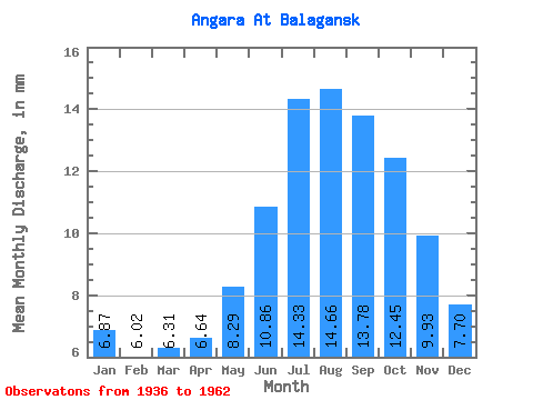
| Statistic | Jan | Feb | Mar | Apr | May | Jun | Jul | Aug | Sep | Oct | Nov | Dec | Annual |
|---|---|---|---|---|---|---|---|---|---|---|---|---|---|
| Mean | 6.87 | 6.07 | 6.31 | 6.64 | 8.29 | 10.86 | 14.33 | 14.65 | 13.78 | 12.45 | 9.93 | 7.70 | 114.77 |
| Standard Deviation | 1.14 | 1.07 | 1.30 | 1.45 | 1.18 | 1.92 | 3.30 | 2.65 | 2.34 | 2.27 | 1.92 | 1.48 | 15.69 |
| Min | 5.30 | 4.29 | 4.62 | 4.84 | 6.22 | 8.06 | 10.68 | 9.59 | 9.40 | 7.32 | 6.06 | 4.71 | 87.41 |
| Max | 8.91 | 7.89 | 9.46 | 9.93 | 10.30 | 16.97 | 21.57 | 18.62 | 18.43 | 17.70 | 14.40 | 9.80 | 142.03 |
| Coefficient of Variation | 0.17 | 0.18 | 0.21 | 0.22 | 0.14 | 0.18 | 0.23 | 0.18 | 0.17 | 0.18 | 0.19 | 0.19 | 0.14 |
 Return to R-Arctic Net Home Page