|
|
|||||||||||||||||
| Point ID: 8116 | Downloads | Plots | Site Data | Code: 1586 |
|
|
|||||||||||||||||
| Download | |
|---|---|
| Site Descriptor Information | Site Time Series Data |
| Link to all available data | |
| View: | Time Series | All |
| Units: | mm |
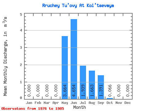
| Statistic | Jan | Feb | Mar | Apr | May | Jun | Jul | Aug | Sep | Oct | Nov | Dec | Annual |
|---|---|---|---|---|---|---|---|---|---|---|---|---|---|
| Mean | 0.00 | 0.00 | 0.00 | 0.00 | 3.66 | 4.65 | 1.94 | 1.66 | 1.39 | 0.07 | 0.00 | 0.00 | 1.11 |
| Standard Deviation | 0.00 | 0.00 | 0.00 | 0.00 | 1.57 | 2.83 | 1.96 | 1.09 | 0.72 | 0.09 | 0.00 | 0.00 | 0.35 |
| Min | 0.00 | 0.00 | 0.00 | 0.00 | 0.62 | 2.00 | 0.16 | 0.38 | 0.33 | 0.00 | 0.00 | 0.00 | 0.66 |
| Max | 0.00 | 0.00 | 0.00 | 0.00 | 5.30 | 12.00 | 6.00 | 3.91 | 2.45 | 0.28 | 0.00 | 0.00 | 1.69 |
| Coefficient of Variation | 0.43 | 0.61 | 1.01 | 0.66 | 0.52 | 1.29 | 0.31 |
 Return to R-Arctic Net Home Page