|
|
|||||||||||||||||
| Point ID: 8116 | Downloads | Plots | Site Data | Code: 1586 |
|
|
|||||||||||||||||
| Download | |
|---|---|
| Site Descriptor Information | Site Time Series Data |
| Link to all available data | |
| View: | Time Series | All |
| Units: | m3/s |
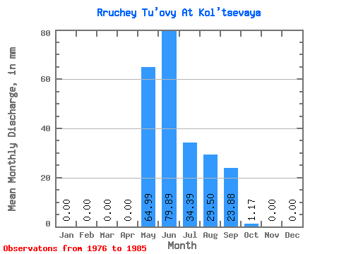
| Statistic | Jan | Feb | Mar | Apr | May | Jun | Jul | Aug | Sep | Oct | Nov | Dec | Annual |
|---|---|---|---|---|---|---|---|---|---|---|---|---|---|
| Mean | 0.00 | 0.00 | 0.00 | 0.00 | 64.98 | 79.89 | 34.39 | 29.49 | 23.88 | 1.17 | 0.00 | 0.00 | 232.99 |
| Standard Deviation | 0.00 | 0.00 | 0.00 | 0.00 | 27.81 | 48.57 | 34.69 | 19.33 | 12.41 | 1.50 | 0.00 | 0.00 | 72.54 |
| Min | 0.00 | 0.00 | 0.00 | 0.00 | 11.00 | 34.33 | 2.84 | 6.74 | 5.67 | 0.00 | 0.00 | 0.00 | 137.68 |
| Max | 0.00 | 0.00 | 0.00 | 0.00 | 94.00 | 205.99 | 106.41 | 69.34 | 42.06 | 4.98 | 0.00 | 0.00 | 352.26 |
| Coefficient of Variation | 0.43 | 0.61 | 1.01 | 0.66 | 0.52 | 1.29 | 0.31 |
 Return to R-Arctic Net Home Page