|
|
|||||||||||||||||
| Point ID: 8086 | Downloads | Plots | Site Data | Code: 1508 |
|
|
|||||||||||||||||
| Download | |
|---|---|
| Site Descriptor Information | Site Time Series Data |
| Link to all available data | |
| View: | Time Series | All |
| Units: | mm |
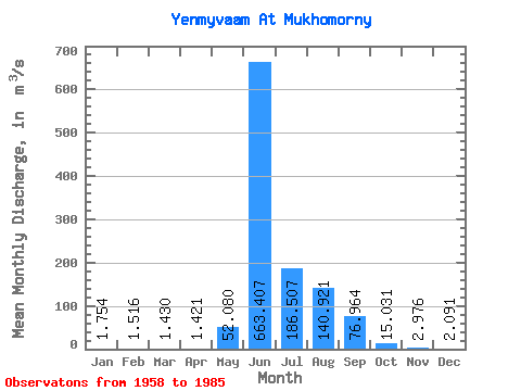
| Statistic | Jan | Feb | Mar | Apr | May | Jun | Jul | Aug | Sep | Oct | Nov | Dec | Annual |
|---|---|---|---|---|---|---|---|---|---|---|---|---|---|
| Mean | 1.75 | 1.52 | 1.43 | 1.42 | 52.08 | 663.41 | 186.51 | 140.92 | 76.96 | 15.03 | 2.98 | 2.09 | 95.95 |
| Standard Deviation | 0.35 | 0.38 | 0.45 | 0.53 | 97.13 | 255.72 | 112.45 | 67.93 | 48.55 | 18.26 | 1.02 | 0.43 | 24.78 |
| Min | 1.14 | 0.92 | 0.55 | 0.42 | 1.84 | 219.00 | 59.10 | 41.40 | 15.30 | 2.56 | 1.27 | 1.14 | 58.62 |
| Max | 2.62 | 2.76 | 2.90 | 2.76 | 497.00 | 1220.00 | 468.00 | 282.00 | 220.00 | 102.00 | 5.83 | 2.98 | 149.66 |
| Coefficient of Variation | 0.20 | 0.25 | 0.31 | 0.37 | 1.86 | 0.39 | 0.60 | 0.48 | 0.63 | 1.22 | 0.34 | 0.20 | 0.26 |
 Return to R-Arctic Net Home Page