|
|
|||||||||||||||||
| Point ID: 8086 | Downloads | Plots | Site Data | Code: 1508 |
|
|
|||||||||||||||||
| Download | |
|---|---|
| Site Descriptor Information | Site Time Series Data |
| Link to all available data | |
| View: | Time Series | All |
| Units: | m3/s |
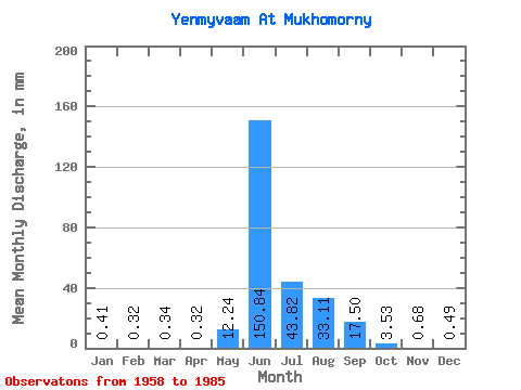
| Statistic | Jan | Feb | Mar | Apr | May | Jun | Jul | Aug | Sep | Oct | Nov | Dec | Annual |
|---|---|---|---|---|---|---|---|---|---|---|---|---|---|
| Mean | 0.41 | 0.32 | 0.34 | 0.32 | 12.23 | 150.84 | 43.81 | 33.10 | 17.50 | 3.53 | 0.68 | 0.49 | 265.64 |
| Standard Deviation | 0.08 | 0.08 | 0.10 | 0.12 | 22.82 | 58.14 | 26.42 | 15.96 | 11.04 | 4.29 | 0.23 | 0.10 | 68.59 |
| Min | 0.27 | 0.20 | 0.13 | 0.10 | 0.43 | 49.79 | 13.88 | 9.72 | 3.48 | 0.60 | 0.29 | 0.27 | 162.28 |
| Max | 0.61 | 0.59 | 0.68 | 0.63 | 116.75 | 277.39 | 109.94 | 66.25 | 50.02 | 23.96 | 1.33 | 0.70 | 414.32 |
| Coefficient of Variation | 0.20 | 0.25 | 0.31 | 0.37 | 1.86 | 0.39 | 0.60 | 0.48 | 0.63 | 1.22 | 0.34 | 0.20 | 0.26 |
 Return to R-Arctic Net Home Page