|
|
|||||||||||||||||
| Point ID: 8035 | Downloads | Plots | Site Data | Code: 1092 |
|
|
|||||||||||||||||
| Download | |
|---|---|
| Site Descriptor Information | Site Time Series Data |
| Link to all available data | |
| View: | Time Series | All |
| Units: | mm |
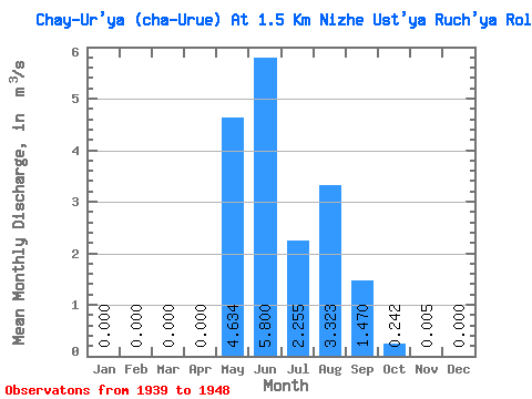
| Statistic | Jan | Feb | Mar | Apr | May | Jun | Jul | Aug | Sep | Oct | Nov | Dec | Annual |
|---|---|---|---|---|---|---|---|---|---|---|---|---|---|
| Mean | 0.00 | 0.00 | 0.00 | 0.00 | 4.63 | 5.80 | 2.25 | 3.32 | 1.47 | 0.24 | 0.01 | 0.00 | 1.41 |
| Standard Deviation | 0.00 | 0.00 | 0.00 | 0.00 | 2.89 | 3.76 | 1.12 | 2.68 | 0.72 | 0.27 | 0.01 | 0.00 | 0.48 |
| Min | 0.00 | 0.00 | 0.00 | 0.00 | 0.52 | 0.89 | 0.75 | 0.75 | 0.38 | 0.01 | 0.00 | 0.00 | 0.88 |
| Max | 0.00 | 0.00 | 0.00 | 0.00 | 10.10 | 13.90 | 4.89 | 9.60 | 2.51 | 0.89 | 0.02 | 0.00 | 2.32 |
| Coefficient of Variation | 3.16 | 0.62 | 0.65 | 0.50 | 0.81 | 0.49 | 1.13 | 1.43 | 3.16 | 0.34 |
 Return to R-Arctic Net Home Page