|
|
|||||||||||||||||
| Point ID: 8035 | Downloads | Plots | Site Data | Code: 1092 |
|
|
|||||||||||||||||
| Download | |
|---|---|
| Site Descriptor Information | Site Time Series Data |
| Link to all available data | |
| View: | Time Series | All |
| Units: | m3/s |
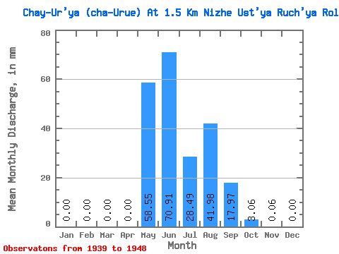
| Statistic | Jan | Feb | Mar | Apr | May | Jun | Jul | Aug | Sep | Oct | Nov | Dec | Annual |
|---|---|---|---|---|---|---|---|---|---|---|---|---|---|
| Mean | 0.00 | 0.00 | 0.00 | 0.00 | 58.54 | 70.92 | 28.49 | 41.98 | 17.97 | 3.05 | 0.06 | 0.00 | 209.14 |
| Standard Deviation | 0.00 | 0.00 | 0.00 | 0.01 | 36.50 | 45.96 | 14.16 | 33.80 | 8.79 | 3.45 | 0.09 | 0.00 | 71.37 |
| Min | 0.00 | 0.00 | 0.00 | 0.00 | 6.58 | 10.88 | 9.47 | 9.47 | 4.65 | 0.10 | 0.00 | 0.00 | 130.76 |
| Max | 0.00 | 0.00 | 0.00 | 0.04 | 127.59 | 169.95 | 61.77 | 121.27 | 30.69 | 11.24 | 0.28 | 0.00 | 345.80 |
| Coefficient of Variation | 3.16 | 0.62 | 0.65 | 0.50 | 0.81 | 0.49 | 1.13 | 1.43 | 3.16 | 0.34 |
 Return to R-Arctic Net Home Page