|
|
|||||||||||||||||
| Point ID: 8016 | Downloads | Plots | Site Data | Code: 3849 |
|
|
|||||||||||||||||
| Download | |
|---|---|
| Site Descriptor Information | Site Time Series Data |
| Link to all available data | |
| View: | Time Series | All |
| Units: | mm |
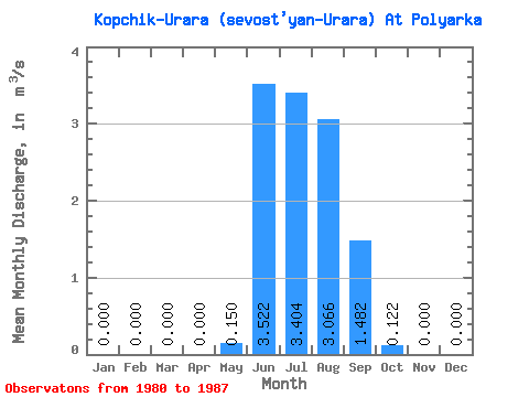
| Statistic | Jan | Feb | Mar | Apr | May | Jun | Jul | Aug | Sep | Oct | Nov | Dec | Annual |
|---|---|---|---|---|---|---|---|---|---|---|---|---|---|
| Mean | 0.00 | 0.00 | 0.00 | 0.00 | 0.15 | 3.52 | 3.40 | 3.07 | 1.48 | 0.12 | 0.00 | 0.00 | 0.94 |
| Standard Deviation | 0.00 | 0.00 | 0.00 | 0.00 | 0.37 | 1.16 | 1.61 | 1.46 | 0.65 | 0.12 | 0.00 | 0.00 | 0.38 |
| Min | 0.00 | 0.00 | 0.00 | 0.00 | 0.00 | 1.73 | 1.53 | 1.24 | 0.72 | 0.02 | 0.00 | 0.00 | 0.63 |
| Max | 0.00 | 0.00 | 0.00 | 0.00 | 0.90 | 5.02 | 6.86 | 6.17 | 2.53 | 0.31 | 0.00 | 0.00 | 1.66 |
| Coefficient of Variation | 2.45 | 0.33 | 0.47 | 0.48 | 0.44 | 0.97 | 0.40 |
 Return to R-Arctic Net Home Page