|
|
|||||||||||||||||
| Point ID: 8016 | Downloads | Plots | Site Data | Code: 3849 |
|
|
|||||||||||||||||
| Download | |
|---|---|
| Site Descriptor Information | Site Time Series Data |
| Link to all available data | |
| View: | Time Series | All |
| Units: | m3/s |
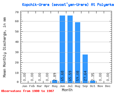
| Statistic | Jan | Feb | Mar | Apr | May | Jun | Jul | Aug | Sep | Oct | Nov | Dec | Annual |
|---|---|---|---|---|---|---|---|---|---|---|---|---|---|
| Mean | 0.00 | 0.00 | 0.00 | 0.00 | 2.89 | 65.69 | 65.58 | 59.08 | 27.64 | 2.36 | 0.00 | 0.00 | 214.29 |
| Standard Deviation | 0.00 | 0.00 | 0.00 | 0.00 | 7.08 | 21.65 | 31.10 | 28.09 | 12.07 | 2.28 | 0.00 | 0.00 | 86.33 |
| Min | 0.00 | 0.00 | 0.00 | 0.00 | 0.00 | 32.26 | 29.48 | 23.89 | 13.43 | 0.35 | 0.00 | 0.00 | 142.47 |
| Max | 0.00 | 0.00 | 0.00 | 0.00 | 17.34 | 93.61 | 132.17 | 118.87 | 47.18 | 5.97 | 0.00 | 0.00 | 375.77 |
| Coefficient of Variation | 2.45 | 0.33 | 0.47 | 0.48 | 0.44 | 0.97 | 0.40 |
 Return to R-Arctic Net Home Page