|
|
|||||||||||||||||
| Point ID: 7996 | Downloads | Plots | Site Data | Code: 3649 |
|
|
|||||||||||||||||
| Download | |
|---|---|
| Site Descriptor Information | Site Time Series Data |
| Link to all available data | |
| View: | Time Series | All |
| Units: | mm |
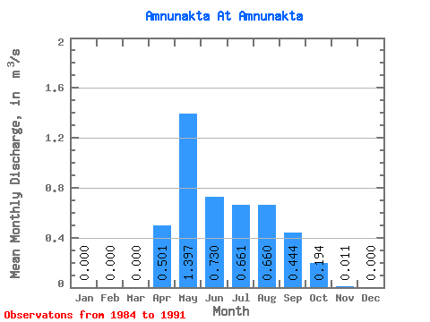
| Statistic | Jan | Feb | Mar | Apr | May | Jun | Jul | Aug | Sep | Oct | Nov | Dec | Annual |
|---|---|---|---|---|---|---|---|---|---|---|---|---|---|
| Mean | 0.00 | 0.00 | 0.00 | 0.50 | 1.40 | 0.73 | 0.66 | 0.66 | 0.44 | 0.19 | 0.01 | 0.00 | 0.46 |
| Standard Deviation | 0.55 | 0.74 | 0.41 | 0.46 | 0.67 | 0.19 | 0.10 | 0.01 | |||||
| Min | 0.00 | 0.00 | 0.00 | 0.06 | 0.62 | 0.26 | 0.09 | 0.22 | 0.16 | 0.07 | 0.00 | 0.00 | 0.46 |
| Max | 0.00 | 0.00 | 0.00 | 1.65 | 2.98 | 1.44 | 1.44 | 2.11 | 0.67 | 0.31 | 0.03 | 0.00 | 0.46 |
| Coefficient of Variation | 1.10 | 0.53 | 0.56 | 0.69 | 1.01 | 0.42 | 0.52 | 0.91 |
 Return to R-Arctic Net Home Page