|
|
|||||||||||||||||
| Point ID: 7996 | Downloads | Plots | Site Data | Code: 3649 |
|
|
|||||||||||||||||
| Download | |
|---|---|
| Site Descriptor Information | Site Time Series Data |
| Link to all available data | |
| View: | Time Series | All |
| Units: | m3/s |
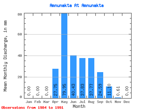
| Statistic | Jan | Feb | Mar | Apr | May | Jun | Jul | Aug | Sep | Oct | Nov | Dec | Annual |
|---|---|---|---|---|---|---|---|---|---|---|---|---|---|
| Mean | 0.00 | 0.00 | 0.00 | 27.74 | 79.95 | 40.43 | 37.84 | 37.77 | 24.61 | 11.11 | 0.58 | 0.00 | 309.19 |
| Standard Deviation | 30.52 | 42.36 | 22.47 | 26.04 | 38.16 | 10.37 | 5.73 | 0.53 | |||||
| Min | 0.00 | 0.00 | 0.00 | 3.10 | 35.48 | 14.40 | 5.09 | 12.59 | 8.86 | 3.95 | 0.00 | 0.00 | 309.19 |
| Max | 0.00 | 0.00 | 0.00 | 91.39 | 170.52 | 79.75 | 82.40 | 120.74 | 37.11 | 17.74 | 1.44 | 0.00 | 309.19 |
| Coefficient of Variation | 1.10 | 0.53 | 0.56 | 0.69 | 1.01 | 0.42 | 0.52 | 0.91 |
 Return to R-Arctic Net Home Page