|
|
|||||||||||||||||
| Point ID: 7992 | Downloads | Plots | Site Data | Code: 3643 |
|
|
|||||||||||||||||
| Download | |
|---|---|
| Site Descriptor Information | Site Time Series Data |
| Link to all available data | |
| View: | Time Series | All |
| Units: | mm |
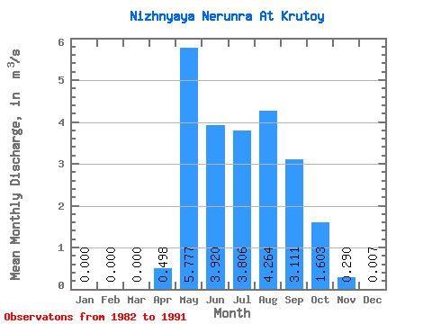
| Statistic | Jan | Feb | Mar | Apr | May | Jun | Jul | Aug | Sep | Oct | Nov | Dec | Annual |
|---|---|---|---|---|---|---|---|---|---|---|---|---|---|
| Mean | 0.00 | 0.00 | 0.00 | 0.50 | 5.78 | 3.92 | 3.81 | 4.26 | 3.11 | 1.60 | 0.29 | 0.01 | 2.34 |
| Standard Deviation | 0.00 | 0.00 | 0.00 | 0.63 | 2.17 | 1.63 | 1.11 | 2.12 | 1.20 | 0.70 | 0.15 | 0.01 | 0.66 |
| Min | 0.00 | 0.00 | 0.00 | 0.00 | 3.87 | 1.76 | 2.24 | 1.88 | 2.25 | 0.95 | 0.06 | 0.00 | 1.64 |
| Max | 0.00 | 0.00 | 0.00 | 1.72 | 10.50 | 6.12 | 5.96 | 7.61 | 5.29 | 3.21 | 0.56 | 0.02 | 2.96 |
| Coefficient of Variation | 1.26 | 0.38 | 0.41 | 0.29 | 0.50 | 0.39 | 0.43 | 0.53 | 1.31 | 0.28 |
 Return to R-Arctic Net Home Page