|
|
|||||||||||||||||
| Point ID: 7992 | Downloads | Plots | Site Data | Code: 3643 |
|
|
|||||||||||||||||
| Download | |
|---|---|
| Site Descriptor Information | Site Time Series Data |
| Link to all available data | |
| View: | Time Series | All |
| Units: | m3/s |
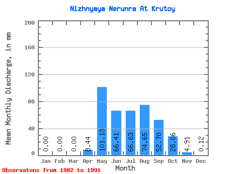
| Statistic | Jan | Feb | Mar | Apr | May | Jun | Jul | Aug | Sep | Oct | Nov | Dec | Annual |
|---|---|---|---|---|---|---|---|---|---|---|---|---|---|
| Mean | 0.00 | 0.00 | 0.00 | 8.43 | 101.12 | 66.41 | 66.62 | 74.63 | 52.71 | 28.05 | 4.91 | 0.12 | 482.58 |
| Standard Deviation | 0.00 | 0.00 | 0.00 | 10.61 | 37.98 | 27.54 | 19.36 | 37.09 | 20.29 | 12.20 | 2.62 | 0.16 | 136.60 |
| Min | 0.00 | 0.00 | 0.00 | 0.00 | 67.74 | 29.82 | 39.21 | 32.91 | 38.12 | 16.63 | 1.02 | 0.00 | 338.15 |
| Max | 0.00 | 0.00 | 0.00 | 29.14 | 183.78 | 103.68 | 104.32 | 133.20 | 89.62 | 56.19 | 9.49 | 0.40 | 609.71 |
| Coefficient of Variation | 1.26 | 0.38 | 0.41 | 0.29 | 0.50 | 0.39 | 0.43 | 0.53 | 1.31 | 0.28 |
 Return to R-Arctic Net Home Page