|
|
|||||||||||||||||
| Point ID: 7979 | Downloads | Plots | Site Data | Code: 3622 |
|
|
|||||||||||||||||
| Download | |
|---|---|
| Site Descriptor Information | Site Time Series Data |
| Link to all available data | |
| View: | Time Series | All |
| Units: | mm |
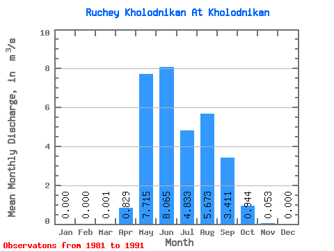
| Statistic | Jan | Feb | Mar | Apr | May | Jun | Jul | Aug | Sep | Oct | Nov | Dec | Annual |
|---|---|---|---|---|---|---|---|---|---|---|---|---|---|
| Mean | 0.00 | 0.00 | 0.00 | 0.83 | 7.71 | 8.06 | 4.83 | 5.67 | 3.41 | 0.94 | 0.05 | 0.00 | 3.24 |
| Standard Deviation | 0.00 | 0.00 | 0.00 | 0.70 | 5.15 | 5.64 | 2.71 | 6.50 | 2.51 | 0.65 | 0.06 | 0.00 | 1.68 |
| Min | 0.00 | 0.00 | 0.00 | 0.00 | 3.04 | 1.74 | 2.85 | 1.51 | 0.48 | 0.21 | 0.00 | 0.00 | 1.46 |
| Max | 0.00 | 0.00 | 0.01 | 1.81 | 21.30 | 22.30 | 12.30 | 24.40 | 8.47 | 2.45 | 0.18 | 0.00 | 5.57 |
| Coefficient of Variation | 2.45 | 0.85 | 0.67 | 0.70 | 0.56 | 1.15 | 0.74 | 0.68 | 1.14 | 2.45 | 0.52 |
 Return to R-Arctic Net Home Page