|
|
|||||||||||||||||
| Point ID: 7979 | Downloads | Plots | Site Data | Code: 3622 |
|
|
|||||||||||||||||
| Download | |
|---|---|
| Site Descriptor Information | Site Time Series Data |
| Link to all available data | |
| View: | Time Series | All |
| Units: | m3/s |
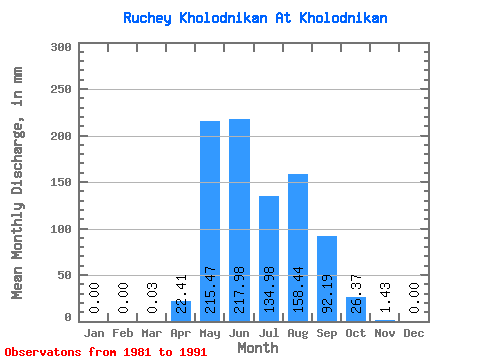
| Statistic | Jan | Feb | Mar | Apr | May | Jun | Jul | Aug | Sep | Oct | Nov | Dec | Annual |
|---|---|---|---|---|---|---|---|---|---|---|---|---|---|
| Mean | 0.00 | 0.00 | 0.02 | 22.41 | 215.43 | 217.99 | 134.95 | 158.41 | 92.19 | 26.36 | 1.43 | 0.01 | 1065.99 |
| Standard Deviation | 0.00 | 0.00 | 0.06 | 19.01 | 143.74 | 152.50 | 75.61 | 181.50 | 67.91 | 18.03 | 1.63 | 0.02 | 552.87 |
| Min | 0.00 | 0.00 | 0.00 | 0.00 | 84.89 | 47.03 | 79.59 | 42.17 | 12.97 | 5.86 | 0.00 | 0.00 | 481.65 |
| Max | 0.00 | 0.00 | 0.14 | 48.92 | 594.80 | 602.73 | 343.48 | 681.37 | 228.93 | 68.42 | 4.87 | 0.06 | 1833.87 |
| Coefficient of Variation | 2.45 | 0.85 | 0.67 | 0.70 | 0.56 | 1.15 | 0.74 | 0.68 | 1.14 | 2.45 | 0.52 |
 Return to R-Arctic Net Home Page