|
|
|||||||||||||||||
| Point ID: 797 | Downloads | Plots | Site Data | Code: 07JF002 |
|
|
|||||||||||||||||
| Download | |
|---|---|
| Site Descriptor Information | Site Time Series Data |
| Link to all available data | |
| View: | Time Series | All |
| Units: | mm |
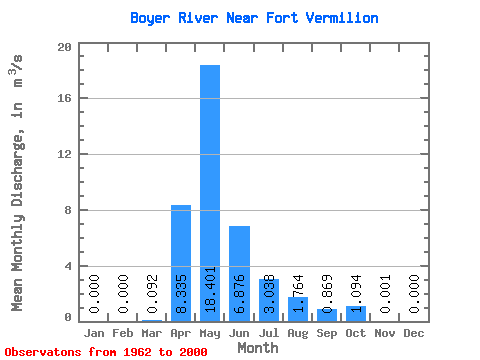
| Statistic | Jan | Feb | Mar | Apr | May | Jun | Jul | Aug | Sep | Oct | Nov | Dec | Annual |
|---|---|---|---|---|---|---|---|---|---|---|---|---|---|
| Mean | 0.00 | 0.00 | 0.09 | 8.34 | 18.40 | 6.88 | 3.04 | 1.76 | 0.87 | 1.09 | 0.00 | 0.00 | |
| Standard Deviation | 0.13 | 9.30 | 21.40 | 11.30 | 5.41 | 4.24 | 2.07 | 2.63 | |||||
| Min | 0.00 | 0.00 | 0.00 | 0.11 | 0.08 | 0.01 | 0.00 | 0.00 | 0.00 | 0.00 | 0.00 | 0.00 | |
| Max | 0.00 | 0.00 | 0.69 | 39.50 | 88.90 | 59.70 | 23.20 | 24.30 | 7.58 | 14.80 | 0.00 | 0.00 | |
| Coefficient of Variation | 1.41 | 1.12 | 1.16 | 1.64 | 1.78 | 2.41 | 2.38 | 2.41 |
 Return to R-Arctic Net Home Page