|
|
|||||||||||||||||
| Point ID: 797 | Downloads | Plots | Site Data | Code: 07JF002 |
|
|
|||||||||||||||||
| Download | |
|---|---|
| Site Descriptor Information | Site Time Series Data |
| Link to all available data | |
| View: | Time Series | All |
| Units: | m3/s |
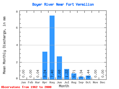
| Statistic | Jan | Feb | Mar | Apr | May | Jun | Jul | Aug | Sep | Oct | Nov | Dec | Annual |
|---|---|---|---|---|---|---|---|---|---|---|---|---|---|
| Mean | 0.00 | 0.00 | 0.04 | 3.24 | 7.40 | 2.68 | 1.22 | 0.71 | 0.34 | 0.44 | 0.00 | 0.00 | |
| Standard Deviation | 0.05 | 3.62 | 8.60 | 4.40 | 2.18 | 1.71 | 0.81 | 1.06 | |||||
| Min | 0.00 | 0.00 | 0.00 | 0.04 | 0.03 | 0.00 | 0.00 | 0.00 | 0.00 | 0.00 | 0.00 | 0.00 | |
| Max | 0.00 | 0.00 | 0.28 | 15.37 | 35.75 | 23.23 | 9.33 | 9.77 | 2.95 | 5.95 | 0.00 | 0.00 | |
| Coefficient of Variation | 1.41 | 1.12 | 1.16 | 1.64 | 1.78 | 2.41 | 2.38 | 2.41 |
 Return to R-Arctic Net Home Page