|
|
|||||||||||||||||
| Point ID: 7951 | Downloads | Plots | Site Data | Code: 3587 |
|
|
|||||||||||||||||
| Download | |
|---|---|
| Site Descriptor Information | Site Time Series Data |
| Link to all available data | |
| View: | Time Series | All |
| Units: | mm |
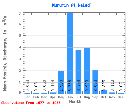
| Statistic | Jan | Feb | Mar | Apr | May | Jun | Jul | Aug | Sep | Oct | Nov | Dec | Annual |
|---|---|---|---|---|---|---|---|---|---|---|---|---|---|
| Mean | 0.06 | 0.06 | 0.06 | 0.11 | 1.99 | 6.97 | 3.76 | 3.93 | 2.07 | 0.33 | 0.11 | 0.07 | 1.67 |
| Standard Deviation | 0.01 | 0.01 | 0.01 | 0.05 | 0.87 | 3.09 | 0.88 | 2.07 | 0.88 | 0.07 | 0.02 | 0.01 | 0.21 |
| Min | 0.05 | 0.05 | 0.05 | 0.05 | 1.12 | 2.50 | 2.65 | 1.50 | 1.09 | 0.26 | 0.09 | 0.06 | 1.44 |
| Max | 0.08 | 0.08 | 0.08 | 0.18 | 3.01 | 10.50 | 5.02 | 6.30 | 3.36 | 0.41 | 0.14 | 0.08 | 1.86 |
| Coefficient of Variation | 0.20 | 0.20 | 0.23 | 0.47 | 0.44 | 0.44 | 0.23 | 0.53 | 0.43 | 0.21 | 0.18 | 0.09 | 0.13 |
 Return to R-Arctic Net Home Page