|
|
|||||||||||||||||
| Point ID: 7951 | Downloads | Plots | Site Data | Code: 3587 |
|
|
|||||||||||||||||
| Download | |
|---|---|
| Site Descriptor Information | Site Time Series Data |
| Link to all available data | |
| View: | Time Series | All |
| Units: | m3/s |
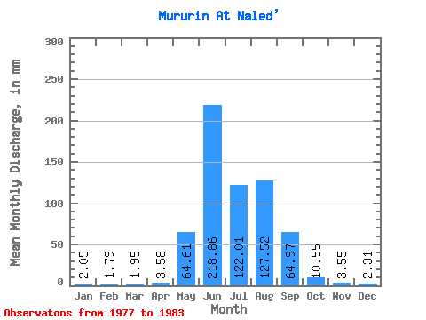
| Statistic | Jan | Feb | Mar | Apr | May | Jun | Jul | Aug | Sep | Oct | Nov | Dec | Annual |
|---|---|---|---|---|---|---|---|---|---|---|---|---|---|
| Mean | 2.04 | 1.80 | 1.95 | 3.59 | 64.60 | 218.86 | 121.99 | 127.50 | 64.97 | 10.55 | 3.54 | 2.31 | 638.40 |
| Standard Deviation | 0.42 | 0.35 | 0.45 | 1.71 | 28.36 | 97.00 | 28.69 | 67.15 | 27.75 | 2.23 | 0.65 | 0.21 | 81.26 |
| Min | 1.62 | 1.48 | 1.56 | 1.57 | 36.36 | 78.55 | 86.02 | 48.69 | 34.25 | 8.44 | 2.83 | 2.01 | 550.20 |
| Max | 2.73 | 2.40 | 2.66 | 5.66 | 97.71 | 329.89 | 162.95 | 204.50 | 105.56 | 13.31 | 4.40 | 2.50 | 710.23 |
| Coefficient of Variation | 0.20 | 0.20 | 0.23 | 0.47 | 0.44 | 0.44 | 0.23 | 0.53 | 0.43 | 0.21 | 0.18 | 0.09 | 0.13 |
 Return to R-Arctic Net Home Page