|
|
|||||||||||||||||
| Point ID: 7947 | Downloads | Plots | Site Data | Code: 3583 |
|
|
|||||||||||||||||
| Download | |
|---|---|
| Site Descriptor Information | Site Time Series Data |
| Link to all available data | |
| View: | Time Series | All |
| Units: | mm |
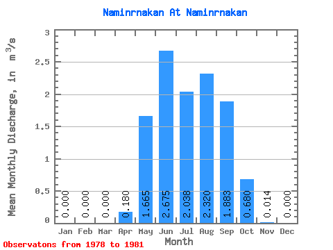
| Statistic | Jan | Feb | Mar | Apr | May | Jun | Jul | Aug | Sep | Oct | Nov | Dec | Annual |
|---|---|---|---|---|---|---|---|---|---|---|---|---|---|
| Mean | 0.00 | 0.00 | 0.00 | 0.18 | 1.67 | 2.67 | 2.04 | 2.32 | 1.88 | 0.68 | 0.01 | 0.00 | 1.03 |
| Standard Deviation | 0.00 | 0.00 | 0.00 | 0.20 | 0.90 | 1.45 | 1.32 | 1.88 | 0.97 | 0.20 | 0.01 | 0.00 | 0.37 |
| Min | 0.00 | 0.00 | 0.00 | 0.00 | 0.33 | 0.93 | 1.28 | 0.58 | 0.85 | 0.44 | 0.01 | 0.00 | 0.73 |
| Max | 0.00 | 0.00 | 0.00 | 0.40 | 2.25 | 4.46 | 4.01 | 4.25 | 2.94 | 0.92 | 0.03 | 0.00 | 1.45 |
| Coefficient of Variation | 1.13 | 0.54 | 0.54 | 0.65 | 0.81 | 0.52 | 0.29 | 0.61 | 0.36 |
 Return to R-Arctic Net Home Page