|
|
|||||||||||||||||
| Point ID: 7947 | Downloads | Plots | Site Data | Code: 3583 |
|
|
|||||||||||||||||
| Download | |
|---|---|
| Site Descriptor Information | Site Time Series Data |
| Link to all available data | |
| View: | Time Series | All |
| Units: | m3/s |
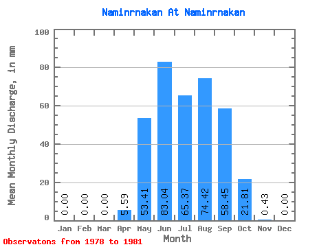
| Statistic | Jan | Feb | Mar | Apr | May | Jun | Jul | Aug | Sep | Oct | Nov | Dec | Annual |
|---|---|---|---|---|---|---|---|---|---|---|---|---|---|
| Mean | 0.00 | 0.00 | 0.00 | 5.59 | 53.40 | 83.04 | 65.35 | 74.41 | 58.44 | 21.81 | 0.43 | 0.00 | 390.00 |
| Standard Deviation | 0.00 | 0.00 | 0.00 | 6.30 | 28.72 | 44.91 | 42.37 | 60.15 | 30.17 | 6.37 | 0.26 | 0.00 | 139.60 |
| Min | 0.00 | 0.00 | 0.00 | 0.00 | 10.58 | 28.87 | 41.05 | 18.60 | 26.39 | 14.11 | 0.25 | 0.00 | 276.92 |
| Max | 0.00 | 0.00 | 0.00 | 12.42 | 72.16 | 138.45 | 128.61 | 136.31 | 91.26 | 29.51 | 0.81 | 0.00 | 546.03 |
| Coefficient of Variation | 1.13 | 0.54 | 0.54 | 0.65 | 0.81 | 0.52 | 0.29 | 0.61 | 0.36 |
 Return to R-Arctic Net Home Page