|
|
|||||||||||||||||
| Point ID: 7943 | Downloads | Plots | Site Data | Code: 3572 |
|
|
|||||||||||||||||
| Download | |
|---|---|
| Site Descriptor Information | Site Time Series Data |
| Link to all available data | |
| View: | Time Series | All |
| Units: | mm |
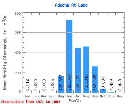
| Statistic | Jan | Feb | Mar | Apr | May | Jun | Jul | Aug | Sep | Oct | Nov | Dec | Annual |
|---|---|---|---|---|---|---|---|---|---|---|---|---|---|
| Mean | 0.01 | 0.00 | 0.00 | 0.01 | 165.85 | 722.06 | 448.16 | 461.34 | 263.40 | 40.60 | 4.43 | 0.45 | 155.49 |
| Standard Deviation | 0.04 | 0.00 | 0.00 | 0.01 | 145.34 | 408.33 | 199.56 | 244.66 | 194.07 | 36.79 | 4.50 | 0.81 | 84.16 |
| Min | 0.00 | 0.00 | 0.00 | 0.00 | 0.00 | 2.96 | 2.38 | 2.14 | 1.67 | 0.60 | 0.00 | 0.00 | 1.72 |
| Max | 0.12 | 0.00 | 0.00 | 0.02 | 442.00 | 1620.00 | 886.00 | 929.00 | 660.00 | 147.00 | 18.60 | 3.06 | 304.45 |
| Coefficient of Variation | 3.02 | 1.88 | 0.88 | 0.57 | 0.45 | 0.53 | 0.74 | 0.91 | 1.01 | 1.80 | 0.54 |
 Return to R-Arctic Net Home Page