|
|
|||||||||||||||||
| Point ID: 7943 | Downloads | Plots | Site Data | Code: 3572 |
|
|
|||||||||||||||||
| Download | |
|---|---|
| Site Descriptor Information | Site Time Series Data |
| Link to all available data | |
| View: | Time Series | All |
| Units: | m3/s |
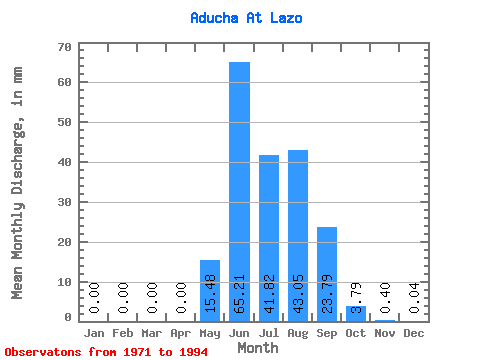
| Statistic | Jan | Feb | Mar | Apr | May | Jun | Jul | Aug | Sep | Oct | Nov | Dec | Annual |
|---|---|---|---|---|---|---|---|---|---|---|---|---|---|
| Mean | 0.00 | 0.00 | 0.00 | 0.00 | 15.48 | 65.21 | 41.82 | 43.05 | 23.79 | 3.79 | 0.40 | 0.04 | 170.99 |
| Standard Deviation | 0.00 | 0.00 | 0.00 | 0.00 | 13.56 | 36.88 | 18.62 | 22.83 | 17.53 | 3.43 | 0.41 | 0.07 | 92.55 |
| Min | 0.00 | 0.00 | 0.00 | 0.00 | 0.00 | 0.27 | 0.22 | 0.20 | 0.15 | 0.06 | 0.00 | 0.00 | 1.89 |
| Max | 0.01 | 0.00 | 0.00 | 0.00 | 41.24 | 146.31 | 82.67 | 86.69 | 59.61 | 13.72 | 1.68 | 0.29 | 334.79 |
| Coefficient of Variation | 3.02 | 1.88 | 0.88 | 0.57 | 0.45 | 0.53 | 0.74 | 0.91 | 1.01 | 1.80 | 0.54 |
 Return to R-Arctic Net Home Page