|
|
|||||||||||||||||
| Point ID: 7939 | Downloads | Plots | Site Data | Code: 3564 |
|
|
|||||||||||||||||
| Download | |
|---|---|
| Site Descriptor Information | Site Time Series Data |
| Link to all available data | |
| View: | Time Series | All |
| Units: | mm |
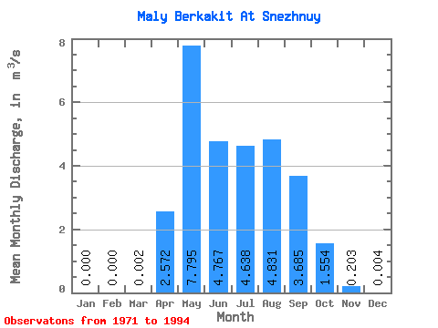
| Statistic | Jan | Feb | Mar | Apr | May | Jun | Jul | Aug | Sep | Oct | Nov | Dec | Annual |
|---|---|---|---|---|---|---|---|---|---|---|---|---|---|
| Mean | 0.00 | 0.00 | 0.00 | 2.57 | 7.79 | 4.77 | 4.64 | 4.83 | 3.69 | 1.55 | 0.20 | 0.00 | 2.60 |
| Standard Deviation | 0.00 | 0.00 | 0.01 | 2.35 | 3.91 | 2.92 | 2.50 | 3.71 | 2.31 | 0.98 | 0.13 | 0.01 | 1.06 |
| Min | 0.00 | 0.00 | 0.00 | 0.00 | 2.24 | 1.27 | 0.37 | 0.43 | 0.05 | 0.02 | 0.00 | 0.00 | 0.36 |
| Max | 0.00 | 0.00 | 0.02 | 7.94 | 15.60 | 12.80 | 10.20 | 14.40 | 7.59 | 3.65 | 0.41 | 0.03 | 3.73 |
| Coefficient of Variation | 3.32 | 0.92 | 0.50 | 0.61 | 0.54 | 0.77 | 0.63 | 0.63 | 0.64 | 2.29 | 0.41 |
 Return to R-Arctic Net Home Page