|
|
|||||||||||||||||
| Point ID: 7939 | Downloads | Plots | Site Data | Code: 3564 |
|
|
|||||||||||||||||
| Download | |
|---|---|
| Site Descriptor Information | Site Time Series Data |
| Link to all available data | |
| View: | Time Series | All |
| Units: | m3/s |
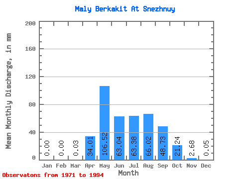
| Statistic | Jan | Feb | Mar | Apr | May | Jun | Jul | Aug | Sep | Oct | Nov | Dec | Annual |
|---|---|---|---|---|---|---|---|---|---|---|---|---|---|
| Mean | 0.00 | 0.00 | 0.02 | 34.01 | 106.50 | 63.04 | 63.37 | 66.01 | 48.73 | 21.23 | 2.68 | 0.06 | 418.04 |
| Standard Deviation | 0.00 | 0.00 | 0.07 | 31.13 | 53.38 | 38.68 | 34.11 | 50.72 | 30.57 | 13.44 | 1.71 | 0.14 | 170.75 |
| Min | 0.00 | 0.00 | 0.00 | 0.00 | 30.61 | 16.80 | 5.05 | 5.88 | 0.70 | 0.25 | 0.00 | 0.00 | 58.79 |
| Max | 0.00 | 0.00 | 0.23 | 105.00 | 213.15 | 169.27 | 139.37 | 196.75 | 100.37 | 49.87 | 5.42 | 0.42 | 601.01 |
| Coefficient of Variation | 3.32 | 0.92 | 0.50 | 0.61 | 0.54 | 0.77 | 0.63 | 0.63 | 0.64 | 2.29 | 0.41 |
 Return to R-Arctic Net Home Page