|
|
|||||||||||||||||
| Point ID: 7930 | Downloads | Plots | Site Data | Code: 3526 |
|
|
|||||||||||||||||
| Download | |
|---|---|
| Site Descriptor Information | Site Time Series Data |
| Link to all available data | |
| View: | Time Series | All |
| Units: | mm |
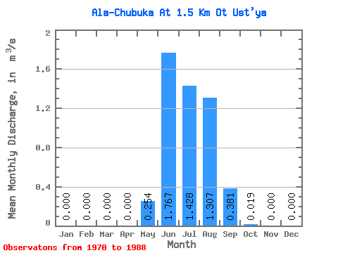
| Statistic | Jan | Feb | Mar | Apr | May | Jun | Jul | Aug | Sep | Oct | Nov | Dec | Annual |
|---|---|---|---|---|---|---|---|---|---|---|---|---|---|
| Mean | 0.00 | 0.00 | 0.00 | 0.00 | 0.25 | 1.77 | 1.43 | 1.31 | 0.38 | 0.02 | 0.00 | 0.00 | 0.39 |
| Standard Deviation | 0.00 | 0.00 | 0.00 | 0.00 | 0.43 | 1.59 | 0.73 | 0.75 | 0.32 | 0.03 | 0.00 | 0.00 | 0.13 |
| Min | 0.00 | 0.00 | 0.00 | 0.00 | 0.00 | 0.32 | 0.41 | 0.20 | 0.06 | 0.00 | 0.00 | 0.00 | 0.21 |
| Max | 0.00 | 0.00 | 0.00 | 0.00 | 1.83 | 7.52 | 3.07 | 3.48 | 1.21 | 0.11 | 0.00 | 0.00 | 0.58 |
| Coefficient of Variation | 1.69 | 0.90 | 0.51 | 0.58 | 0.83 | 1.34 | 0.34 |
 Return to R-Arctic Net Home Page