|
|
|||||||||||||||||
| Point ID: 7930 | Downloads | Plots | Site Data | Code: 3526 |
|
|
|||||||||||||||||
| Download | |
|---|---|
| Site Descriptor Information | Site Time Series Data |
| Link to all available data | |
| View: | Time Series | All |
| Units: | m3/s |
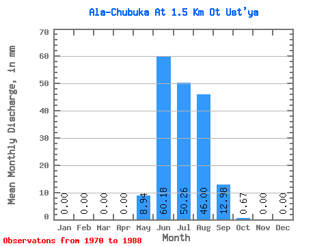
| Statistic | Jan | Feb | Mar | Apr | May | Jun | Jul | Aug | Sep | Oct | Nov | Dec | Annual |
|---|---|---|---|---|---|---|---|---|---|---|---|---|---|
| Mean | 0.00 | 0.00 | 0.00 | 0.00 | 8.95 | 60.19 | 50.26 | 45.99 | 12.96 | 0.68 | 0.00 | 0.00 | 161.76 |
| Standard Deviation | 0.00 | 0.00 | 0.00 | 0.00 | 15.14 | 54.21 | 25.55 | 26.47 | 10.75 | 0.92 | 0.00 | 0.00 | 54.69 |
| Min | 0.00 | 0.00 | 0.00 | 0.00 | 0.00 | 10.90 | 14.43 | 7.04 | 1.87 | 0.00 | 0.00 | 0.00 | 86.36 |
| Max | 0.00 | 0.00 | 0.00 | 0.00 | 64.40 | 256.13 | 108.03 | 122.46 | 41.21 | 3.87 | 0.00 | 0.00 | 240.71 |
| Coefficient of Variation | 1.69 | 0.90 | 0.51 | 0.58 | 0.83 | 1.34 | 0.34 |
 Return to R-Arctic Net Home Page