|
|
|||||||||||||||||
| Point ID: 7918 | Downloads | Plots | Site Data | Code: 3478 |
|
|
|||||||||||||||||
| Download | |
|---|---|
| Site Descriptor Information | Site Time Series Data |
| Link to all available data | |
| View: | Time Series | All |
| Units: | mm |
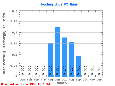
| Statistic | Jan | Feb | Mar | Apr | May | Jun | Jul | Aug | Sep | Oct | Nov | Dec | Annual |
|---|---|---|---|---|---|---|---|---|---|---|---|---|---|
| Mean | 0.00 | 0.00 | 0.00 | 0.00 | 0.15 | 0.22 | 0.18 | 0.16 | 0.10 | 0.00 | 0.00 | 0.00 | 0.06 |
| Standard Deviation | 0.00 | 0.00 | 0.00 | 0.00 | 0.14 | 0.15 | 0.15 | 0.13 | 0.16 | 0.00 | 0.00 | 0.00 | 0.03 |
| Min | 0.00 | 0.00 | 0.00 | 0.00 | 0.00 | 0.02 | 0.03 | 0.03 | 0.00 | 0.00 | 0.00 | 0.00 | 0.01 |
| Max | 0.00 | 0.00 | 0.00 | 0.00 | 0.59 | 0.59 | 0.64 | 0.59 | 0.89 | 0.01 | 0.00 | 0.00 | 0.12 |
| Coefficient of Variation | 0.95 | 0.65 | 0.85 | 0.81 | 1.68 | 2.31 | 0.41 |
 Return to R-Arctic Net Home Page