|
|
|||||||||||||||||
| Point ID: 7918 | Downloads | Plots | Site Data | Code: 3478 |
|
|
|||||||||||||||||
| Download | |
|---|---|
| Site Descriptor Information | Site Time Series Data |
| Link to all available data | |
| View: | Time Series | All |
| Units: | m3/s |
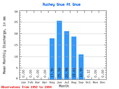
| Statistic | Jan | Feb | Mar | Apr | May | Jun | Jul | Aug | Sep | Oct | Nov | Dec | Annual |
|---|---|---|---|---|---|---|---|---|---|---|---|---|---|
| Mean | 0.00 | 0.00 | 0.00 | 0.00 | 17.94 | 25.60 | 20.96 | 18.55 | 10.93 | 0.15 | 0.00 | 0.00 | 86.67 |
| Standard Deviation | 0.00 | 0.00 | 0.00 | 0.00 | 16.97 | 16.73 | 17.73 | 15.01 | 18.34 | 0.35 | 0.00 | 0.00 | 35.20 |
| Min | 0.00 | 0.00 | 0.00 | 0.00 | 0.12 | 1.95 | 3.44 | 3.79 | 0.12 | 0.00 | 0.00 | 0.00 | 21.41 |
| Max | 0.00 | 0.00 | 0.00 | 0.00 | 69.91 | 67.67 | 75.84 | 69.91 | 102.07 | 1.66 | 0.00 | 0.00 | 172.93 |
| Coefficient of Variation | 0.95 | 0.65 | 0.85 | 0.81 | 1.68 | 2.31 | 0.41 |
 Return to R-Arctic Net Home Page