|
|
|||||||||||||||||
| Point ID: 7913 | Downloads | Plots | Site Data | Code: 3448 |
|
|
|||||||||||||||||
| Download | |
|---|---|
| Site Descriptor Information | Site Time Series Data |
| Link to all available data | |
| View: | Time Series | All |
| Units: | mm |
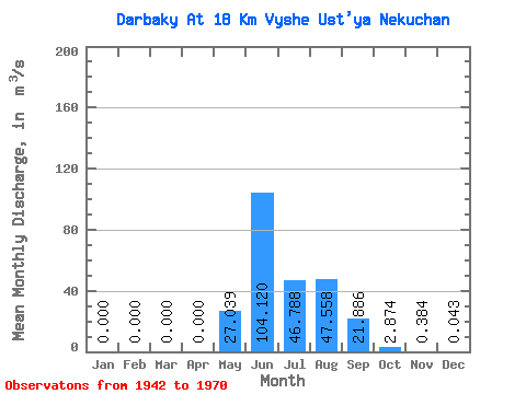
| Statistic | Jan | Feb | Mar | Apr | May | Jun | Jul | Aug | Sep | Oct | Nov | Dec | Annual |
|---|---|---|---|---|---|---|---|---|---|---|---|---|---|
| Mean | 0.00 | 0.00 | 0.00 | 0.00 | 27.04 | 104.12 | 46.79 | 47.56 | 21.89 | 2.87 | 0.38 | 0.04 | 20.89 |
| Standard Deviation | 0.00 | 0.00 | 0.00 | 0.00 | 19.36 | 66.70 | 29.22 | 34.71 | 17.98 | 3.46 | 0.58 | 0.14 | 8.06 |
| Min | 0.00 | 0.00 | 0.00 | 0.00 | 0.37 | 29.50 | 12.70 | 5.61 | 4.01 | 0.52 | 0.00 | 0.00 | 8.73 |
| Max | 0.00 | 0.00 | 0.00 | 0.00 | 83.20 | 301.00 | 129.00 | 114.00 | 72.50 | 17.50 | 2.85 | 0.70 | 42.49 |
| Coefficient of Variation | 5.00 | 0.72 | 0.64 | 0.62 | 0.73 | 0.82 | 1.20 | 1.51 | 3.23 | 0.39 |
 Return to R-Arctic Net Home Page