|
|
|||||||||||||||||
| Point ID: 7913 | Downloads | Plots | Site Data | Code: 3448 |
|
|
|||||||||||||||||
| Download | |
|---|---|
| Site Descriptor Information | Site Time Series Data |
| Link to all available data | |
| View: | Time Series | All |
| Units: | m3/s |
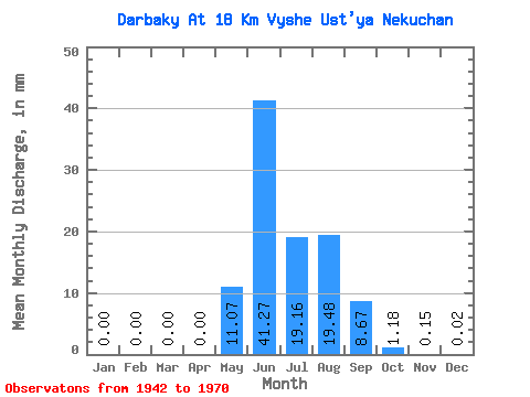
| Statistic | Jan | Feb | Mar | Apr | May | Jun | Jul | Aug | Sep | Oct | Nov | Dec | Annual |
|---|---|---|---|---|---|---|---|---|---|---|---|---|---|
| Mean | 0.00 | 0.00 | 0.00 | 0.00 | 11.07 | 41.27 | 19.16 | 19.47 | 8.67 | 1.18 | 0.15 | 0.02 | 100.81 |
| Standard Deviation | 0.00 | 0.00 | 0.00 | 0.00 | 7.93 | 26.43 | 11.97 | 14.21 | 7.13 | 1.42 | 0.23 | 0.06 | 38.92 |
| Min | 0.00 | 0.00 | 0.00 | 0.00 | 0.15 | 11.69 | 5.20 | 2.30 | 1.59 | 0.21 | 0.00 | 0.00 | 42.11 |
| Max | 0.00 | 0.00 | 0.00 | 0.00 | 34.07 | 119.30 | 52.82 | 46.68 | 28.73 | 7.17 | 1.13 | 0.29 | 205.05 |
| Coefficient of Variation | 5.00 | 0.72 | 0.64 | 0.62 | 0.73 | 0.82 | 1.20 | 1.51 | 3.23 | 0.39 |
 Return to R-Arctic Net Home Page