|
|
|||||||||||||||||
| Point ID: 7908 | Downloads | Plots | Site Data | Code: 3428 |
|
|
|||||||||||||||||
| Download | |
|---|---|
| Site Descriptor Information | Site Time Series Data |
| Link to all available data | |
| View: | Time Series | All |
| Units: | mm |
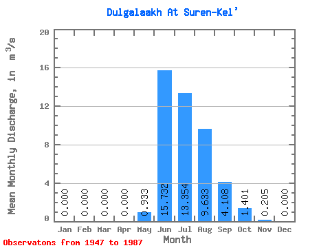
| Statistic | Jan | Feb | Mar | Apr | May | Jun | Jul | Aug | Sep | Oct | Nov | Dec | Annual |
|---|---|---|---|---|---|---|---|---|---|---|---|---|---|
| Mean | 0.00 | 0.00 | 0.00 | 0.00 | 0.93 | 15.73 | 13.35 | 9.63 | 4.11 | 1.40 | 0.20 | 0.00 | 3.91 |
| Standard Deviation | 0.00 | 0.00 | 0.00 | 0.00 | 0.91 | 7.11 | 5.57 | 4.23 | 1.48 | 0.51 | 0.21 | 0.00 | 0.89 |
| Min | 0.00 | 0.00 | 0.00 | 0.00 | 0.00 | 0.00 | 6.25 | 4.32 | 1.92 | 0.65 | 0.00 | 0.00 | 2.46 |
| Max | 0.00 | 0.00 | 0.00 | 0.00 | 4.13 | 34.00 | 25.00 | 22.30 | 7.81 | 2.52 | 0.68 | 0.01 | 6.60 |
| Coefficient of Variation | 5.75 | 5.75 | 5.75 | 5.75 | 0.98 | 0.45 | 0.42 | 0.44 | 0.36 | 0.36 | 1.01 | 3.99 | 0.23 |
 Return to R-Arctic Net Home Page