|
|
|||||||||||||||||
| Point ID: 7908 | Downloads | Plots | Site Data | Code: 3428 |
|
|
|||||||||||||||||
| Download | |
|---|---|
| Site Descriptor Information | Site Time Series Data |
| Link to all available data | |
| View: | Time Series | All |
| Units: | m3/s |
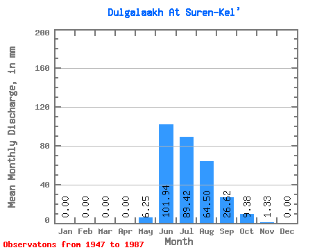
| Statistic | Jan | Feb | Mar | Apr | May | Jun | Jul | Aug | Sep | Oct | Nov | Dec | Annual |
|---|---|---|---|---|---|---|---|---|---|---|---|---|---|
| Mean | 0.00 | 0.00 | 0.00 | 0.00 | 6.25 | 101.94 | 89.40 | 64.50 | 26.62 | 9.38 | 1.33 | 0.00 | 308.52 |
| Standard Deviation | 0.00 | 0.00 | 0.00 | 0.00 | 6.12 | 46.05 | 37.30 | 28.33 | 9.62 | 3.41 | 1.34 | 0.01 | 70.49 |
| Min | 0.00 | 0.00 | 0.00 | 0.00 | 0.00 | 0.01 | 41.84 | 28.92 | 12.44 | 4.35 | 0.00 | 0.00 | 194.16 |
| Max | 0.01 | 0.01 | 0.01 | 0.01 | 27.65 | 220.32 | 167.38 | 149.30 | 50.61 | 16.87 | 4.41 | 0.05 | 520.61 |
| Coefficient of Variation | 5.75 | 5.75 | 5.75 | 5.75 | 0.98 | 0.45 | 0.42 | 0.44 | 0.36 | 0.36 | 1.01 | 3.99 | 0.23 |
 Return to R-Arctic Net Home Page