|
|
|||||||||||||||||
| Point ID: 7904 | Downloads | Plots | Site Data | Code: 3411 |
|
|
|||||||||||||||||
| Download | |
|---|---|
| Site Descriptor Information | Site Time Series Data |
| Link to all available data | |
| View: | Time Series | All |
| Units: | mm |
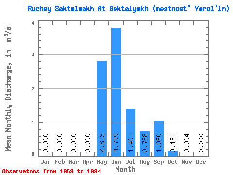
| Statistic | Jan | Feb | Mar | Apr | May | Jun | Jul | Aug | Sep | Oct | Nov | Dec | Annual |
|---|---|---|---|---|---|---|---|---|---|---|---|---|---|
| Mean | 0.00 | 0.00 | 0.00 | 0.00 | 2.81 | 3.80 | 1.40 | 0.74 | 1.05 | 0.16 | 0.00 | 0.00 | 0.75 |
| Standard Deviation | 0.00 | 0.00 | 0.00 | 0.00 | 1.81 | 1.82 | 1.24 | 0.74 | 0.98 | 0.15 | 0.01 | 0.00 | 0.29 |
| Min | 0.00 | 0.00 | 0.00 | 0.00 | 0.12 | 1.27 | 0.06 | 0.13 | 0.13 | 0.01 | 0.00 | 0.00 | 0.26 |
| Max | 0.00 | 0.00 | 0.00 | 0.00 | 5.90 | 7.75 | 4.88 | 3.01 | 3.96 | 0.55 | 0.03 | 0.00 | 1.44 |
| Coefficient of Variation | 0.64 | 0.48 | 0.89 | 1.00 | 0.94 | 0.95 | 2.23 | 0.39 |
 Return to R-Arctic Net Home Page