|
|
|||||||||||||||||
| Point ID: 7904 | Downloads | Plots | Site Data | Code: 3411 |
|
|
|||||||||||||||||
| Download | |
|---|---|
| Site Descriptor Information | Site Time Series Data |
| Link to all available data | |
| View: | Time Series | All |
| Units: | m3/s |
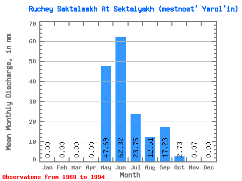
| Statistic | Jan | Feb | Mar | Apr | May | Jun | Jul | Aug | Sep | Oct | Nov | Dec | Annual |
|---|---|---|---|---|---|---|---|---|---|---|---|---|---|
| Mean | 0.00 | 0.00 | 0.00 | 0.00 | 47.68 | 62.32 | 23.74 | 12.51 | 17.22 | 2.73 | 0.07 | 0.00 | 150.12 |
| Standard Deviation | 0.00 | 0.00 | 0.00 | 0.00 | 30.59 | 29.84 | 21.02 | 12.54 | 16.09 | 2.59 | 0.16 | 0.00 | 58.21 |
| Min | 0.00 | 0.00 | 0.00 | 0.00 | 2.03 | 20.83 | 1.05 | 2.20 | 2.13 | 0.19 | 0.00 | 0.00 | 52.37 |
| Max | 0.00 | 0.00 | 0.00 | 0.00 | 100.00 | 127.14 | 82.71 | 51.02 | 64.96 | 9.32 | 0.51 | 0.00 | 286.84 |
| Coefficient of Variation | 0.64 | 0.48 | 0.89 | 1.00 | 0.94 | 0.95 | 2.23 | 0.39 |
 Return to R-Arctic Net Home Page