|
|
|||||||||||||||||
| Point ID: 7902 | Downloads | Plots | Site Data | Code: 3408 |
|
|
|||||||||||||||||
| Download | |
|---|---|
| Site Descriptor Information | Site Time Series Data |
| Link to all available data | |
| View: | Time Series | All |
| Units: | mm |
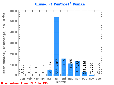
| Statistic | Jan | Feb | Mar | Apr | May | Jun | Jul | Aug | Sep | Oct | Nov | Dec | Annual |
|---|---|---|---|---|---|---|---|---|---|---|---|---|---|
| Mean | 8.16 | 3.98 | 3.01 | 3.22 | 541.00 | 5354.17 | 1583.62 | 1121.38 | 1340.23 | 358.14 | 71.05 | 21.00 | 859.37 |
| Standard Deviation | 5.11 | 1.54 | 1.15 | 1.38 | 1066.76 | 1747.81 | 813.41 | 765.12 | 824.88 | 244.16 | 42.34 | 15.30 | 190.52 |
| Min | 2.88 | 1.53 | 1.40 | 1.00 | 1.57 | 2930.00 | 334.00 | 290.00 | 102.00 | 40.90 | 18.70 | 7.13 | 493.09 |
| Max | 22.00 | 6.15 | 5.17 | 5.32 | 3590.00 | 8530.00 | 2950.00 | 2750.00 | 2920.00 | 1040.00 | 171.00 | 67.30 | 1136.94 |
| Coefficient of Variation | 0.63 | 0.39 | 0.38 | 0.43 | 1.97 | 0.33 | 0.51 | 0.68 | 0.61 | 0.68 | 0.60 | 0.73 | 0.22 |
 Return to R-Arctic Net Home Page