|
|
|||||||||||||||||
| Point ID: 7902 | Downloads | Plots | Site Data | Code: 3408 |
|
|
|||||||||||||||||
| Download | |
|---|---|
| Site Descriptor Information | Site Time Series Data |
| Link to all available data | |
| View: | Time Series | All |
| Units: | m3/s |
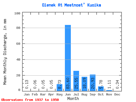
| Statistic | Jan | Feb | Mar | Apr | May | Jun | Jul | Aug | Sep | Oct | Nov | Dec | Annual |
|---|---|---|---|---|---|---|---|---|---|---|---|---|---|
| Mean | 0.13 | 0.06 | 0.05 | 0.05 | 8.73 | 83.60 | 25.55 | 18.09 | 20.93 | 5.78 | 1.11 | 0.34 | 163.38 |
| Standard Deviation | 0.08 | 0.02 | 0.02 | 0.02 | 17.21 | 27.29 | 13.12 | 12.34 | 12.88 | 3.94 | 0.66 | 0.25 | 36.22 |
| Min | 0.05 | 0.02 | 0.02 | 0.02 | 0.03 | 45.75 | 5.39 | 4.68 | 1.59 | 0.66 | 0.29 | 0.12 | 93.75 |
| Max | 0.35 | 0.09 | 0.08 | 0.08 | 57.92 | 133.19 | 47.59 | 44.36 | 45.59 | 16.78 | 2.67 | 1.09 | 216.16 |
| Coefficient of Variation | 0.63 | 0.39 | 0.38 | 0.43 | 1.97 | 0.33 | 0.51 | 0.68 | 0.61 | 0.68 | 0.60 | 0.73 | 0.22 |
 Return to R-Arctic Net Home Page