|
|
|||||||||||||||||
| Point ID: 7889 | Downloads | Plots | Site Data | Code: 3374 |
|
|
|||||||||||||||||
| Download | |
|---|---|
| Site Descriptor Information | Site Time Series Data |
| Link to all available data | |
| View: | Time Series | All |
| Units: | mm |
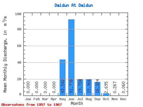
| Statistic | Jan | Feb | Mar | Apr | May | Jun | Jul | Aug | Sep | Oct | Nov | Dec | Annual |
|---|---|---|---|---|---|---|---|---|---|---|---|---|---|
| Mean | 0.00 | 0.00 | 0.00 | 0.00 | 43.54 | 91.78 | 19.73 | 19.97 | 16.32 | 2.69 | 0.27 | 0.06 | 16.33 |
| Standard Deviation | 0.00 | 0.00 | 0.00 | 0.00 | 29.45 | 30.21 | 23.77 | 24.76 | 12.43 | 2.06 | 0.80 | 0.18 | 4.29 |
| Min | 0.00 | 0.00 | 0.00 | 0.00 | 1.88 | 46.30 | 0.68 | 0.52 | 0.70 | 0.00 | 0.00 | 0.00 | 10.03 |
| Max | 0.00 | 0.00 | 0.00 | 0.00 | 91.60 | 139.00 | 70.90 | 65.10 | 39.40 | 5.03 | 2.40 | 0.54 | 23.10 |
| Coefficient of Variation | 0.68 | 0.33 | 1.20 | 1.24 | 0.76 | 0.77 | 3.00 | 3.00 | 0.26 |
 Return to R-Arctic Net Home Page