|
|
|||||||||||||||||
| Point ID: 7889 | Downloads | Plots | Site Data | Code: 3374 |
|
|
|||||||||||||||||
| Download | |
|---|---|
| Site Descriptor Information | Site Time Series Data |
| Link to all available data | |
| View: | Time Series | All |
| Units: | m3/s |
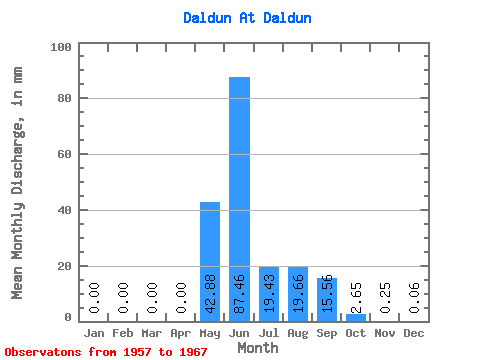
| Statistic | Jan | Feb | Mar | Apr | May | Jun | Jul | Aug | Sep | Oct | Nov | Dec | Annual |
|---|---|---|---|---|---|---|---|---|---|---|---|---|---|
| Mean | 0.00 | 0.00 | 0.00 | 0.00 | 42.87 | 87.46 | 19.43 | 19.66 | 15.55 | 2.65 | 0.25 | 0.06 | 189.49 |
| Standard Deviation | 0.00 | 0.00 | 0.00 | 0.00 | 28.99 | 28.79 | 23.40 | 24.38 | 11.84 | 2.03 | 0.76 | 0.18 | 49.73 |
| Min | 0.00 | 0.00 | 0.00 | 0.00 | 1.85 | 44.12 | 0.67 | 0.51 | 0.67 | 0.00 | 0.00 | 0.00 | 116.33 |
| Max | 0.00 | 0.00 | 0.00 | 0.00 | 90.19 | 132.46 | 69.81 | 64.09 | 37.55 | 4.95 | 2.29 | 0.53 | 268.06 |
| Coefficient of Variation | 0.68 | 0.33 | 1.20 | 1.24 | 0.76 | 0.77 | 3.00 | 3.00 | 0.26 |
 Return to R-Arctic Net Home Page