|
|
|||||||||||||||||
| Point ID: 7882 | Downloads | Plots | Site Data | Code: 3359 |
|
|
|||||||||||||||||
| Download | |
|---|---|
| Site Descriptor Information | Site Time Series Data |
| Link to all available data | |
| View: | Time Series | All |
| Units: | mm |
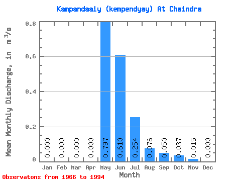
| Statistic | Jan | Feb | Mar | Apr | May | Jun | Jul | Aug | Sep | Oct | Nov | Dec | Annual |
|---|---|---|---|---|---|---|---|---|---|---|---|---|---|
| Mean | 0.00 | 0.00 | 0.00 | 0.00 | 0.80 | 0.61 | 0.25 | 0.08 | 0.05 | 0.04 | 0.01 | 0.00 | 0.15 |
| Standard Deviation | 0.00 | 0.00 | 0.00 | 0.00 | 0.58 | 0.25 | 0.24 | 0.07 | 0.06 | 0.05 | 0.04 | 0.00 | 0.07 |
| Min | 0.00 | 0.00 | 0.00 | 0.00 | 0.01 | 0.16 | 0.06 | 0.00 | 0.00 | 0.00 | 0.00 | 0.00 | 0.04 |
| Max | 0.00 | 0.00 | 0.00 | 0.00 | 2.13 | 1.30 | 1.31 | 0.26 | 0.24 | 0.19 | 0.16 | 0.00 | 0.27 |
| Coefficient of Variation | 0.72 | 0.41 | 0.96 | 0.86 | 1.12 | 1.27 | 2.38 | 4.58 | 0.46 |
 Return to R-Arctic Net Home Page