|
|
|||||||||||||||||
| Point ID: 7882 | Downloads | Plots | Site Data | Code: 3359 |
|
|
|||||||||||||||||
| Download | |
|---|---|
| Site Descriptor Information | Site Time Series Data |
| Link to all available data | |
| View: | Time Series | All |
| Units: | m3/s |
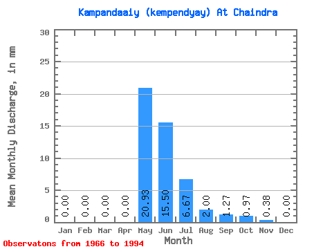
| Statistic | Jan | Feb | Mar | Apr | May | Jun | Jul | Aug | Sep | Oct | Nov | Dec | Annual |
|---|---|---|---|---|---|---|---|---|---|---|---|---|---|
| Mean | 0.00 | 0.00 | 0.00 | 0.00 | 20.93 | 15.50 | 6.67 | 1.99 | 1.26 | 0.98 | 0.38 | 0.00 | 47.44 |
| Standard Deviation | 0.00 | 0.00 | 0.00 | 0.00 | 15.14 | 6.43 | 6.39 | 1.71 | 1.42 | 1.25 | 0.91 | 0.02 | 21.56 |
| Min | 0.00 | 0.00 | 0.00 | 0.00 | 0.24 | 4.07 | 1.68 | 0.10 | 0.00 | 0.00 | 0.00 | 0.00 | 11.60 |
| Max | 0.00 | 0.00 | 0.00 | 0.00 | 55.92 | 33.03 | 34.39 | 6.83 | 6.10 | 4.99 | 4.07 | 0.08 | 81.94 |
| Coefficient of Variation | 0.72 | 0.41 | 0.96 | 0.86 | 1.12 | 1.27 | 2.38 | 4.58 | 0.46 |
 Return to R-Arctic Net Home Page