|
|
|||||||||||||||||
| Point ID: 7872 | Downloads | Plots | Site Data | Code: 3341 |
|
|
|||||||||||||||||
| Download | |
|---|---|
| Site Descriptor Information | Site Time Series Data |
| Link to all available data | |
| View: | Time Series | All |
| Units: | mm |
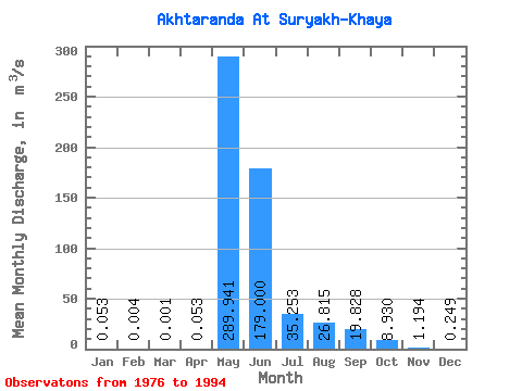
| Statistic | Jan | Feb | Mar | Apr | May | Jun | Jul | Aug | Sep | Oct | Nov | Dec | Annual |
|---|---|---|---|---|---|---|---|---|---|---|---|---|---|
| Mean | 0.05 | 0.00 | 0.00 | 0.05 | 289.94 | 179.00 | 35.25 | 26.82 | 19.83 | 8.93 | 1.19 | 0.25 | 43.18 |
| Standard Deviation | 0.05 | 0.01 | 0.00 | 0.14 | 136.31 | 116.94 | 43.99 | 47.31 | 22.91 | 10.48 | 1.44 | 0.27 | 14.40 |
| Min | 0.00 | 0.00 | 0.00 | 0.00 | 110.00 | 33.10 | 6.80 | 0.84 | 0.47 | 0.53 | 0.15 | 0.01 | 15.68 |
| Max | 0.15 | 0.03 | 0.01 | 0.47 | 568.00 | 348.00 | 177.00 | 178.00 | 65.10 | 34.40 | 5.68 | 1.02 | 62.41 |
| Coefficient of Variation | 0.93 | 2.00 | 3.32 | 2.67 | 0.47 | 0.65 | 1.25 | 1.76 | 1.16 | 1.17 | 1.21 | 1.09 | 0.33 |
 Return to R-Arctic Net Home Page